
avalanche danger
MTC053-061-089-241400-
BACKCOUNTRY AVALANCHE WARNING
Forest Service Idaho Panhandle Avalanche Center Sandpoint ID
Relayed by National Weather Service Missoula MT
742 AM MST Tue Feb 23 2021
The following message is transmitted at the request of the Forest
Service Idaho Panhandle Avalanche Center Sandpoint ID
...The Forest Service Idaho Panhandle Avalanche Center Sandpoint
ID has issued a Backcountry Avalanche Warning...
-
WHAT...The avalanche danger is HIGH. Rapid new snow loading with
snow and winds overlying buried weak layers. Very dangerous
avalanche conditions exist. Expect to see natural avalanches and
human triggered avalanches. -
WHERE...St. Regis Basin in Lookout Pass Zone, Kootenay/Cabinet
MT Zone. -
WHEN...In effect until 7 AM MST Wednesday.
-
IMPACTS...Recent heavy snow combined with strong winds will
likely create widespread areas of unstable snow. Remotely
triggered avalanches are likely. Avoid traveling in or below
steep terrain above 5000 feet in elevation.
PRECAUTIONARY/PREPAREDNESS ACTIONS...
Very dangerous avalanche conditions. Travel on and below steep
slopes is not recommended. Avalanches may run long distances and
can run into mature forests, valley floors, or flat terrain.
Consult http://www.idahopanhandleavalanche.org for more detailed
information.
Similar avalanche danger may exist at locations outside the
coverage area of any Avalanche Center.
&&
$$
MTC029-047-241300-
BACKCOUNTRY AVALANCHE WARNING
Forest Service Flathead Avalanche Center Kalispell MT
Relayed by National Weather Service Missoula MT
617 AM MST Tue Feb 23 2021
The following message is transmitted at the request of the Forest
Service Flathead Avalanche Center Kalispell MT
...The Forest Service Flathead Avalanche Center Kalispell MT has issued
a Backcountry Avalanche Warning...
-
WHAT...The avalanche danger is HIGH.
-
WHERE...Flathead Range and Swan Ranges, and the Lake MacDonald
and Marias Pass areas of Glacier National Park. -
WHEN...In effect until 6 AM MST Wednesday
-
IMPACTS...Recent and drifted snow is overloading fragile,
reactive weak layers. It will easy to trigger large, wide, and
deadly avalanches. Natural avalanches may run long distances.
PRECAUTIONARY/PREPAREDNESS ACTIONS...
Avoid riding or traveling in or below avalanche terrain.
Consult http://www.flatheadavalanche.org for more detailed
information.
Similar avalanche danger may exist at locations outside the
coverage area of any Avalanche Center.
&&
$$
MTC063-081-240100-
BACKCOUNTRY AVALANCHE WARNING
Forest Service West Central Montana Avalanche Center Missoula MT
Relayed by National Weather Service Missoula MT
614 PM MST Mon Feb 22 2021
The following message is transmitted at the request of the Forest
Service West Central Montana Avalanche Center Missoula MT
...The Forest Service West Central Montana Avalanche Center
Missoula MT has issued a Backcountry Avalanche Warning...
-
WHAT...The avalanche danger is HIGH.
-
WHERE...southern Mission, southern Swan, Rattlesnake, and
southern and central Bitterroot Mountains. -
WHEN...In effect until 6 PM MST Tuesday.
-
IMPACTS...New snow, weak layers in the snowpack, and strong
winds are creating very dangerous avalanche conditions.
PRECAUTIONARY/PREPAREDNESS ACTIONS...
Very dangerous avalanche conditions. Travel in avalanche terrain
is not recommended. Avoid being under run-out zones, avalanches
may be remotely triggered, and run to historic limits.
Consult http://www.missoulaavalanche.org for more detailed
information.
Similar avalanche danger may exist at locations outside the
coverage area of any Avalanche Center.
Hello Read This Please
From The nwsgsp Team To Your Naborhood, We Will Not tolerate Any Off Topic Comments Sorry Hope You Stay Safe
The NWS GSP Team
No CommentURGENT - WINTER WEATHER MESSAGE
URGENT - WINTER WEATHER MESSAGE
National Weather Service Great Falls MT
342 AM MST Mon Feb 22 2021
MTZ009-222300-
/O.CON.KTFX.BZ.W.0001.000000T0000Z-210223T1800Z/
Northern Rocky Mountain Front-
Including Logan Pass
342 AM MST Mon Feb 22 2021
...BLIZZARD WARNING REMAINS IN EFFECT
UNTIL 11 AM MST TUESDAY ABOVE 4500 FEET...
-
WHAT...Blizzard conditions occurring above 4500 feet. Additional
snow accumulations of 3 to 6 inches at lower elevations and 8 to
16 inches in the mountains. Winds gusting as high as 75 mph. -
WHERE...Northern Rocky Mountain Front.
-
WHEN...Until 11 AM MST Tuesday.
-
IMPACTS...Travel could be very difficult to impossible.
Widespread blowing snow will reduce visibility to near zero at
times.
PRECAUTIONARY/PREPAREDNESS ACTIONS...
Travel should be restricted to emergencies only. If you must
travel, have a winter survival kit with you. If you get stranded,
stay with your vehicle.
The latest road conditions for the state you are calling from can
be obtained by calling 5 1 1.
Special Weather Statement
Special Weather Statement
National Weather Service Greenville-Spartanburg SC
1024 PM EST Sun Feb 21 2021
NCZ033-035>037-048>053-056>059-062>065-069-501>507-509-221515-
Avery-Alexander-Iredell-Davie-Madison-Yancey-Mitchell-Swain-
Haywood-Buncombe-Catawba-Rowan-Graham-Northern Jackson-Macon-
Southern Jackson-Transylvania-Henderson-Lincoln-
Caldwell Mountains-Greater Caldwell-Burke Mountains-Greater Burke-
McDowell Mountains-Eastern McDowell-Rutherford Mountains-
Polk Mountains-
Including the cities of Ingalls, Banner Elk, Newland, Bethlehem,
Ellendale, Millersville, Taylorsville, Hiddenite, Stony Point,
Statesville, Mooresville, Farmington, Fork Church, Mocksville,
Advance, Faust, Mars Hill, Marshall, Walnut, Allenstand,
Hot Springs, Luck, Swiss, Burnsville, Celo, Micaville,
Ramseytown, Busick, Spruce Pine, Poplar, Alarka, Almond,
Bryson City, Luada, Wesser, Waynesville, Waterville, Canton,
Cruso, Cove Creek, Asheville, Black Mountain, Candler, Hickory,
Newton, St. Stephens, Salisbury, Robbinsville, Stecoah,
Cullowhee, Tuckasegee, Sylva, Franklin, Rainbow Springs, Kyle,
Highlands, Wolf Mountain, Cashiers, Brevard, Cedar Mountain,
Little River, Hendersonville, Fletcher, Dana, East Flat Rock,
Tuxedo, Etowah, Lincolnton, Crouse, Patterson, Kings Creek,
Lenoir, Sawmills, Granite Falls, Jonas Ridge, Morganton,
Pleasant Grove, Valdese, Ashford, Sugar Hill, Woodlawn, Old Fort,
Marion, Nebo, Dysartsville, Fero, Glenwood,
Chimney Rock State Park, and Saluda
1024 PM EST Sun Feb 21 2021
...A BRIEF WINTRY MIX EXPECTED ACROSS PORTIONS OF WESTERN NORTH
CAROLINA LATE TONIGHT AND MONDAY MORNING...
Precipitation is expected to overspread western North Carolina and
parts of North East Georgia from the southwest beginning around
midnight and continuing into the daylight hours Monday. Locations
across the mountains, as well as along and north of the I-40
corridor in the Piedmont and foothills are expected to be around
freezing when the precipitation begins. This could result in a
brief period of a wintry mix, with freezing rain likely being the
most prevalent precipitation type. Spotty light accumulations of
ice and perhaps sleet are possible across the area. Locations that
do see freezing rain are likely to see ice accumulations from
trace amounts to only a few hundreths of an inch, mainly on
elevated surfaces such as trees and power lines. Locally higher
amounts are possible, especially along the Blue Ridge escarpment.
Widespread travel issues are not expected due to relatively warm
road temperatures, but a few slick spots could develop on bridges
and overpasses.
As temperatures warm above freezing after sunrise, the threat from
freezing rain will end, with all areas expected to be above
freezing by late morning.
Hazardous Weather Outlook
Hazardous Weather Outlook
National Weather Service Greenville-Spartanburg SC
537 AM EST Sun Feb 21 2021
NCZ033-035-048>050-053-065-501>507-509-221045-
Avery-Alexander-Madison-Yancey-Mitchell-Buncombe-Henderson-
Caldwell Mountains-Greater Caldwell-Burke Mountains-Greater Burke-
McDowell Mountains-Eastern McDowell-Rutherford Mountains-
Polk Mountains-
537 AM EST Sun Feb 21 2021
This Hazardous Weather Outlook is for the mountains and foothills of
North Carolina.
.DAY ONE...Today and tonight.
Precipitation is expected to develop across the central and northern
mountains and foothills of North Carolina after midnight. Some of the
precipitation may fall as a wintry mix of freezing rain and sleet,
particularly along and near the Blue Ridge Escarpment, through
daybreak on Monday. A light accumulation of sleet and ice is
possible.
.DAYS TWO THROUGH SEVEN...Monday through Saturday.
Some light freezing rain may persist near the Blue Ridge Escarpment
through the middle part of Monday morning, before changing to all
rain by late morning.
.SPOTTER INFORMATION STATEMENT...
None.
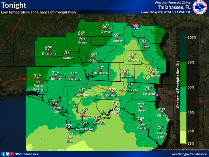
No CommentNWS Forecast Office Tallahassee, FL
Forecast
Tonight's forecast for the western Carolinas and northeast Georgia #ncwx #scwx #gawx
No Comment
Tornado Warning
WPC_MD 0025 affecting Southeast GA, eastern SC and southern NC, #ncwx #scwx #gawx, https://go.usa.gov/xsb6N
https://origin.wpc.ncep.noaa.gov/metwatch/images/mcd0025.gif
No Comment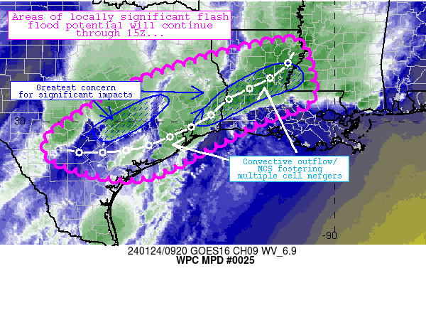